Maps & Directions
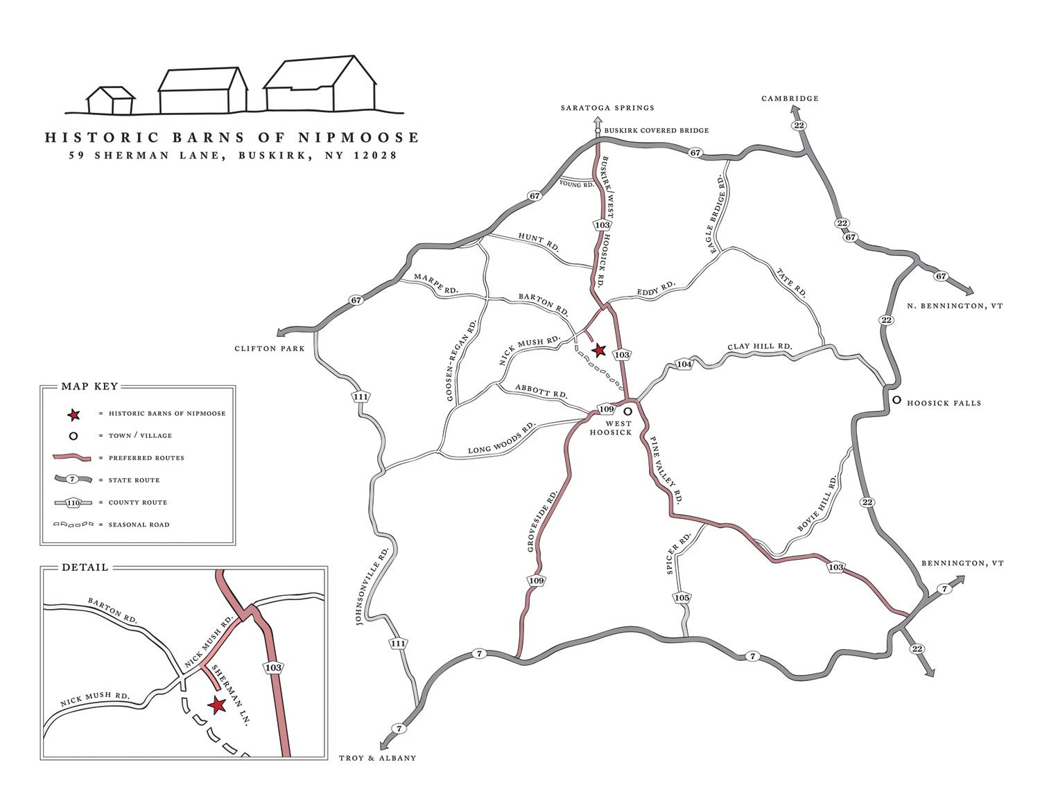
Please review the detailed directions below to help avoid misadventures over seasonal roads.
Our Location
The Historic Barns of Nipmoose are located in a pastoral area called Buskirk in northeastern Rensselaer County, NY. Directions to the barns provided by some navigational systems offer routes over poorly maintained roads. Please review our detailed directions to help avoid misadventures.
Historic Barns of Nipmoose
59 Sherman Lane
Buskirk, NY 12028
View a PDF of the Local Map.
Directions to the Nipmoose Barns
from the NORTH
Travel time from Saratoga Springs, NY, approximately 50 minutes
Merge onto I-87 S. Take Exit 15 toward Rte. 29E/Schuylerville. Take NY Rte. 29/Gen. Philip Schuyler Commemorative Hwy. going East toward Wooley Road. Continue to follow NY Rte. 29 for 6.1 miles into Schuylerville. Turn right onto Broadway/US Rte.4/NY Rte. 29/NY Rte. 32 for 0.3 miles. Turn left onto Ferry St/NY Rte. 29. Continue to follow NY Rte. 29 for 5.1 miles into Greenwich. Stay straight to go onto Main St/NY Rte. 372. Continue to follow NY Rte. 372 for 8.9 miles into Cambridge. Turn right onto S. Park St/NY Rte. 22. Continue to follow NY Rte. 22 for 5.4 miles. Turn right onto NY Rte. 67 toward Eagle Bridge and go 3.2 miles. In Buskirk, turn left onto County Route 103. Go 2.5 miles. Turn right onto Nick Mush Road. Go 0.4 miles and turn left onto Sherman Lane. The Barns are at the top of the hill.
from the SOUTH
Travel time from Hudson, NY, approximately 90 minutes
Take NY Rte. 23B East 3.9 miles. NY Rte. 23B becomes NY Rte. 23. Merge onto the Taconic State Parkway N and go 14.5 miles to the last exit before the toll (Chatham/East Chatham Exit). Bear left on ramp and turn right onto Rte. 295 East. Go 4.4 miles. Turn left onto County Rte. 5. Go 4.2 miles. Turn right onto US Rte. 20/Columbia Turnpike. Go 2 miles through the village of New Lebanon. Turn slight left onto NY Rte. 22. Go 29 miles to a tee. Turn right onto NY Rte. 7 and take an almost immediate left onto Pine Valley Road (County Rte. 103). Rte. 103 has several turns, so watch signs. Go 7.5 miles. At sharp turn, stay straight onto Nick Mush Road. Go 0.4 miles and turn left onto Sherman Lane. The Barns are at the top of the hill.
from the SOUTHWEST
Travel time from New York City, NY, approximately 3 hours 20 minutes
Travel time from Albany, NY, approximately 45 minutes
Take I-87N/NY State Thruway N. Merge onto I-787N via exit 23 toward Downtown Albany/Rensselaer/Troy. Go 6.7 miles. Merge onto NY Rte. 7E via Exit 9E toward Troy/Bennington. Go 15.5 miles. Turn slight left onto Simmons Road/County Rte. 109 for 0.1 miles. Turn left immediately onto Groveside Road/County Rte. 109, go 4.5 miles. Turn left onto Buskirk West Hoosick Road/County Rte. 103, go 1.5 miles. Turn slight left onto Nick Mush Road, go 0.4 miles and turn left onto Sherman Lane. The Barns are at the top of the hill.
from the EAST
Travel time from Boston, MA, approximately 3 hours 20 minutes
Travel time from Bennington, VT, approximately 30 minutes
From Rte. 67A turn left onto Rte. 67. Follow for 8.3 miles through Walloomsac and North Hoosick (here Rte. 67 will merge with Rte. 22). Stay straight on Rte. 67/Rte. 22. At blinking light near Benson’s Restaurant, turn left onto Rte. 67 and go 3 miles, passing through Eagle Bridge. In Buskirk, turn left onto County Rte. 103. Go 2.5 miles. Turn right onto Nick Mush Road. Go 0.4 miles and turn left onto Sherman Lane. The Barns are at the top of the hill.
from the SOUTHEAST
Travel time from Williamstown, MA, approximately 45 minutes
From Massachusetts/MA Rte. 2 turn right onto North St./US Rte. 7 for 4.2 miles (crossing into Vermont). Turn left onto VT Rte. 346 for 7.2 miles, passing through Pownal (crossing into New York). Turn right onto NY Rte. 22 for 2.2 miles to a tee. Turn right onto NY Rte. 7 and take an almost immediate left onto Pine Valley Road (County Rte. 103). Rte. 103 has several turns, so watch signs. Go 7.5 miles. At sharp turn, stay straight onto Nick Mush Road. Go 0.4 miles and turn left onto Sherman Lane. The Barns are at the top of the hill.
from the WEST
Travel time from Clifton Park, NY, approximately 30 minutes
At the intersection of Rte. 9 and NY-146, take NY-146 E/Clifton Park Blvd. for 5 miles. Turn left to stay on NY-146 E for 2.7 miles. NY-146 E becomes US-4 N/NY-32 N. In Mechanicville turn right onto Park Ave. for 0.1 miles and then turn left onto Main St. N for 0.3 miles. Turn right onto NY-67 and go 5.6 miles. Turn left onto NY-40/NY-67 for 1.5 miles passing through Schaghticoke. Turn right onto NY-67 for 1.4 miles. After crossing the bridge in Valley Falls, turn left to stay on NY-67 for 7.8 miles. In Buskirk, turn right onto County Route 103. Go 2.5 miles. Turn right onto Nick Mush Road. Go 0.4 miles and turn left onto Sherman Lane. The Barns are at the top of the hill.

